
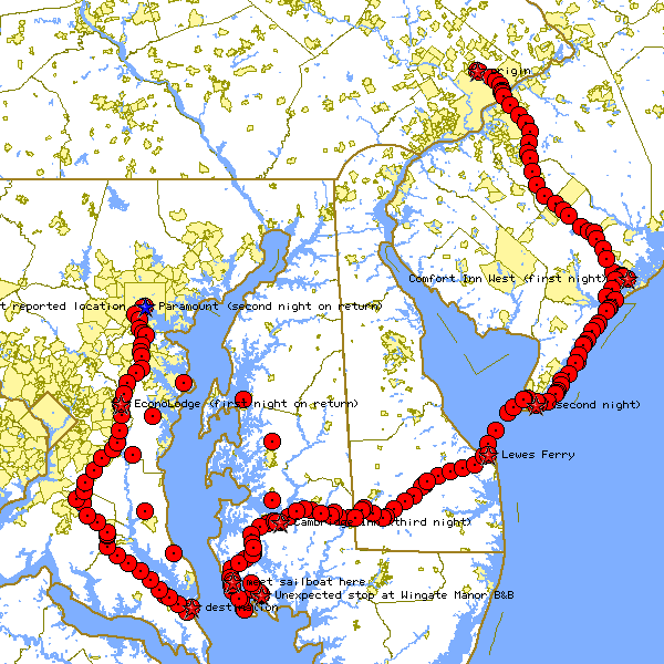
Having not quite run out of directions to bike in, Scott and I decided to try east this year. Actually, southeast. This picture (created by the TIGER mapping service, a free service of the census bureau) shows our route of travel, as sent from the gear on my bike. It's just a picture, in case TIGER goes down one day and never comes back up.
I used to have an interactive map CGI script here which let you pan, zoom, and whatnot. In today's Google Maps world it's now passe, and I'm not investing the time to keep this old mule plowing.
The pictures from the trip are all in this directory listing.
And lastly, if you're interested in how all of this technology is
jumbled together in order to create a live updating web page, I've now created an overview of the method.
Trip Log
Total mileage (biking) for six days of travel: 333 miles
- Day 1: we made it to Atlantic City pretty much right on schedule. Apparently the waypoint data uploaded shortly after lunch made the TIGER mapping service freak out, returning broken images. Also, we've found that the QuickCam is really bad at taking pictures in full daylight: setting the camera to its lowest brightness and highest contrast, it barely manages to show the outlines of objects. I need to find some sunglasses for it. After arriving at the hotel, we took a short side trip to the Atlantic City boardwalk. Miles for the day: just over 70.
- Day 2: We got up early expecting a long days' ride. As it turns out, the GPS was confused about where we were starting the day from: it thought we were starting in Cape May, biking to Atlantic City in a straight line, and then biking back to Cape May! Once we got underway, it realized that we weren't anywhere near Cape May, and reported the correct distance. To compensate, we decided to bike slowly (under 12 mph) and enjoy a long lunch in Sea Isle City. After lunch, we sat on the boardwalk behind the beach (because I didn't think that I needed any more sun) and spent a half-hour playing air hockey and Ms. PacMan. We had a slight delay as we entered Wildwood when we had to change Scott's flat rear tire, and found the going a little rough through Wildwood (between the crowds of cars and rough condition of the roads), but managed to make it to our destination around 5:30. We stopped at a drug store early on to take care of the QuickCam washed-out picture problem: we bought a high-tech filter (a pair of $8.00 sunglasses), snapped them into four pieces, and taped one lens over the QuickCam. The pictures look much better! We're planning on an early start tomorrow, catching the 8:40 Lewes Ferry. So, after having dinner with Scott's Aunt and visiting the Dairy Queen in downtown Cape May, we're turning in early. Miles for the day: just over 50.
- Day 3: The day started off smoothly. We left early, caught the ferry with time to spare, and had a smooth 14 mph ride on the ferry. The roads are well paved, but the sun is really beating down today, and I'm sucking down my water faster than usual. As we approached Georgetown, we found that all of the restaurants were closed for the holiday! Continuing on a little further, we found a strip mall with an open pizza place. At the pizza place, I found that the connector from the laptop to the GPS was disconnected (which is why there are no red dots from the ferry to where we had lunch). Before the trip, I picked out two routes for the second half of the day: the first leading south, toward the Woodland Ferry (a cute free two-minute ferry ride), and the second leading slightly north, avoiding the ferry (but two miles shorter). We decided to head for the ferry to try to find shade on some of the smaller side roads. We had limited success, and stopped at just about every chance we could. We arrived at the Cambridge Inn (our stop for the night) at about 6:00 PM. Miles for the day: just over 67.
- Day 4: We've got a short ride today (only about 23 miles), so
we decided to sleep in. We'll be starting off at about 11 am, and should
be meeting our friends with the sailboat at about 2. The wind on the way
was very oppressive, keeping us under 10 mph while quickly sapping my
strength. We arrived at the bridge to meet the sailboat just before 2,
making a quick trip into the nearby town of Fishing Creek to pick up
lunch. We waited from 2 until 4 for the sailboat, at which point we
started calling people. It turns out that our friends got off to a late
start, and that they were a few miles to our west at that point. Due to
some miscommunication of where we thought we were and where they thought
they were, we (collectively) thought that they were 12 miles south of us!
We sped south about 8 miles, only to find that there were no roads that
went farther south. Some locals confirmed that we couldn't possibly bike
any further south, and we called the sailboat again (thank God for
cellular phones). Well, the sailboat couldn't make it in to the dock
(because the water was too shallow), so Chuck took the canoe to the dock.
Apparently, this was an hour-long trip: had we been at the dock still
(which
was where we were waiting), we would have had to have taken two trips with the canoe to get the three of us and two bikes to the sailboat, which would have meant arriving back on the west side of the bay at about 2 in the morning. As it was, they weren't willing to take two more canoe trips in, so they started sailing back. We went back to the shop, and the owner (John) nicely drove us to a nearby Bed & Breakfast (the Wingate Manor), whose proprietors (Jorge (!) and Emily) gladly took us in (and drove us to a nearby store for dinner). Chuck's new plan is to drive around tomorrow and pick us up with his car (which is preferable to the alternate plan of turning around and starting homeward). The GPS data cable snapped in the morning as we left, which meant that the live-updating web page was't live-updating. Using a lighter and a pair of wire cutters, I managed to get the GPS data cable reconnected enough to transfer today's tracking. Also, we've recreated the missing waypoints from the first half of day 3 (so that everyone can now see the pictures taken then). We'll be recreating the missing waypoints for today when we have a chance. Miles for the day: just over 43 (about twice what we expected). - Day 5: Our friends Gena and Chuck are driving around the bay from Lexington Park, MD (our destination) to the B&B (which I heartily recommend that you visit if you're in the area). They should be here by noon, at which point I'll set up the computer gear to take pictures from the car. We're not doing any biking today. I've recreated the data for day 4's trip, so the pictures should be visible now.
- Day 6: Today we rest. We'll be starting off for Bowie tomorrow morning. The pictures from the car trip on day 5 had problems, which have been resolved.
- Day 7: The weather today was fabulous: low 80's with light cloud cover. We made excellent time, covering just over 70 miles. Today's total brings us just over the 300 mile mark: last year we covered just under 300 miles over 8 days (five biking, three resting). This year, we expect to cover about 325 miles in eight days (with only two resting).
- Day 8: The weather wasn't quite as nice as yesterday, but it was still a fabulous day. We wound up biking more than 30 miles, rather than the 23 planned, due to some navigational problems. Also, Baltimore has the worst hills of the trip so far (which are still mild in comparison to the hills we've dealt with on other trips). We arrived at our hotel just after 2 pm.